
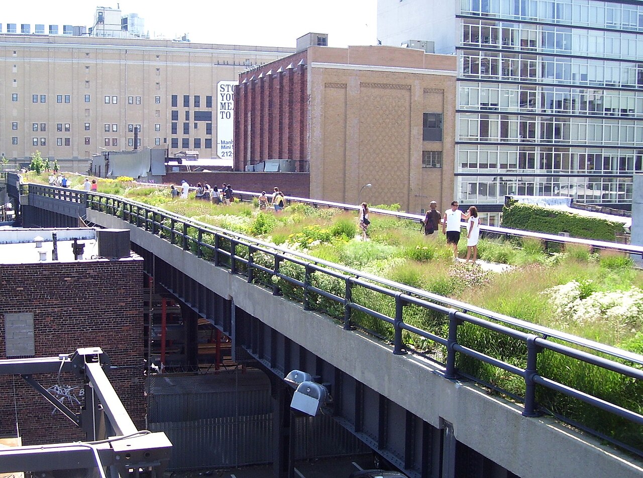
The High Line (2026) Visitor Guide: All 11 Entrances, Elevators & Seasonal Hours
Free Walk-Up Access| Street Access Point | Elevator / ADA? | Adjacent Landmarks & Nearest Subway |
|---|---|---|
| Gansevoort St & Washington St (South Start) | Yes (Elevator + Stairs) | Whitney Museum of American Art, Little Island (Pier 55), 14th St (A/C/E/L) |
| West 14th Street & Tenth Ave | Yes (Elevator + Stairs) | Tiffany & Co. Foundation Overlook, Pier 57 Rooftop Park |
| West 16th Street & Tenth Ave | Yes (Elevator + Stairs) | Direct pass-through inside National Biscuit Co. / Chelsea Market viaduct arch |
| West 17th Street (10th Ave Square) | Stairs Only | 10th Avenue sunken glass amphitheater framing downtown taxi traffic below |
| West 23rd Street & Tenth Ave | Yes (Elevator + Stairs) | Lawn steps, West Chelsea art galleries, London Terrace Gardens (23rd C/E) |
| West 26th / 28th / 30th Streets | W 30th St Elevator | Zaha Hadid 520 W 28th, The Spur Plinth & Moynihan Train Hall Connector |
| West 34th Street (North End Ramp) | Yes (Step-Free Ramp) | Hudson Yards Vessel, Edge Observation Deck, Javits Center, 34th St–Hudson Yards (7 train) |
1. From "Death Avenue" to 1934 Engineering Marvel: The West Side Improvement
To understand the structural bone structure of The High Line, one must travel back to the mid-19th century, when the Hudson River Railroad laid street-level freight tracks directly down Tenth and Eleventh avenues in 1847 to supply Manhattan's slaughterhouses, cold-storage meatpacking depots, and baked-goods factories. Because massive coal-fired locomotives shared pavement with horse-drawn wagons, pushcarts, and crowded tenement sidewalks, accidents occurred with horrifying frequency. So many pedestrians were crushed along Tenth Avenue that locals nicknamed the corridor "Death Avenue," and the railroad hired horsemen known as "West Side Cowboys" to ride ahead of locomotives waving red flags by day and red lanterns by night.
After six decades of public outcry, New York State, New York City, and the New York Central Railroad signed the monumental West Side Improvement Project in 1929—at $150 million (over $2.7 billion today), the largest public-private infrastructure venture of the Great Depression. Chief engineer Robert Moses (in his early regional planning years) and railroad structural engineers designed the southern leg between 34th Street and Spring Street not as an elevated subway trestle running down the avenue, but as a bespoke, mid-block elevated steel viaduct engineered to fly cleanly right through the interior centers of heavy brick industrial warehouses so trains could load and unload raw milk, beef, and Nabisco biscuits directly inside factory floors.
Opened to freight traffic in 1934, the 30-foot-wide deck was heavily over-engineered: riveted Bethlehem Steel plate girders supported a reinforced-concrete ballast tub capable of carrying two fully loaded freight trains simultaneously. By the 1960s, however, interstate trucking captured Manhattan's parcel freight, the southern Spring Street extension was demolished, and in 1980 the final train—three boxcars carrying frozen turkeys—rumbled along the rusted rails above Gansevoort Street.
The High Line Route Map: Gansevoort St to Hudson Yards & Entrances
Trace the elevated golden steel alignment from the Whitney Museum (Gansevoort St) through Chelsea Market, West 20th St Galleries, and The Spur Plinth to Hudson Yards & Edge. Click any pin for elevator access notes.
2. Friends of the High Line & Diller Scofidio + Renfro’s "Agri-tecture"
For nearly twenty years after freight operations ceased, CSX Transportation owned the abandoned structure while West Chelsea real estate owners lobbied Mayor Rudy Giuliani to demolish the "rusting eyesore" to widen lots for development. In 1999, neighborhood residents Joshua David and Robert Hammond attended a Chelsea Community Board 4 meeting and co-founded the non-profit Friends of the High Line—inspired after photographer Joel Sternfeld revealed that wildflower meadows, sumac trees, and birch groves had spontaneously colonized the ballast gravel high above traffic.
Following a 2003 international ideas competition, the city selected landscape architects James Corner Field Operations, architecture studio Diller Scofidio + Renfro (DS+R), and Dutch planting designer Piet Oudolf. Rather than pave over the viaduct like a conventional sidewalk, DS+R coined the philosophy of "Agri-tecture": every precast concrete paving plank was engineered with tapered comb-like edges and open longitudinal joints so wild grasses and sedums could literally sprout out between the stones, blurring the boundary between industrial steel path and self-seeding meadow.
Structurally, preservationists sandblasted the 1934 riveted steel I-beams, waterproofed the concrete deck tub, and re-laid sections of the original steel freight tracks at their exact historic gauge—transforming the rusted rail alignment into a seamless promenade elevated 18 to 30 feet above the West Side street grid charted in our NYC Cartographic Grid Analysis.
3. Piet Oudolf’s Four-Season Ecological & Microclimate Matrix
Planting an exposed railway deck three stories above Hudson River salt winds presents acute horticultural challenges: shallow soil beds (ranging from 14 inches to 36 inches deep), freezing winter drafts beneath the open steel belly, and intense summer solar reflection off adjacent glass curtain walls. Dutch "New Perennial" pioneer Piet Oudolf selected more than 500 drought-tolerant native species chosen not merely for summer blossoms, but for winter seed-head silhouettes, autumn amber grasses, and wildlife pollination value:
Between West 13th and 16th streets, rainwater collected from the concrete paving channels sustains sunken woodland thickets of serviceberry (Amelanchier), grey birch, sweetbay magnolia, and ostrich ferns thriving in shaded microclimates.
Between 18th and 28th streets, little bluestem, purple coneflower (Echinacea), prairie dropseed, and blazing star stand intentionally uncut throughout winter to catch snow, before being sheared down annually each March during Spring Cutback.
4. Architectural Corridor: Frank Gehry, Zaha Hadid & The Piercing Buildings
Walkers strolling north along The High Line experience an open-air museum of 21st-century Pritzker Prize architecture triggered directly by the 2005 Special West Chelsea Rezoning, which allowed property owners to sell "air rights" over the tracks eastward in exchange for preserving views along the park:
- The Standard, High Line (848 Washington St, Polshek Partnership, 2009): Straddling the tracks on massive Y-shaped concrete piers above 13th Street so the viaduct passes cleanly underneath the hotel lobby belly.
- Chelsea Market Passage (450 West 15th St, 1890s): The High Line slices physically through the interior masonry archways of the old National Biscuit Company complex (where the Oreo cookie was invented in 1912), shielded from wind and rain inside an industrial loading bay.
- IAC Building (555 W 18th St, Frank Gehry): Before sculpting 8 Spruce Street in Lower Manhattan, Frank Gehry completed his first New York building overlooking the High Line—a sail-like white fritted-glass headquarters paired with Jean Nouvel’s mosaic-windowed 100 Eleventh Avenue immediately to the north.
- 520 West 28th Street (Zaha Hadid): Rising directly beside the 28th Street promenade stands the late Dame Zaha Hadid's sole New York City residential tower, defined by interlocking hand-rubbed chevron steel ribbons wrapping curved double-height glass apartments.
5. The Spur, The Plinth & Hudson Yards Skywalk Extensions
At West 30th Street and Tenth Avenue, the final phase of The High Line splits into two distinct prongs. To the west, the main promenade sweeps around the massive Hudson Yards concrete deck—passing directly alongside The Vessel, 30 Hudson Yards (home to the 1,131-foot Edge outdoor sky deck), and curving north alongside Twelfth Avenue to a final wild-rail meadow terminating at West 34th Street.
To the east at 30th Street sits The Spur (opened in 2019), the park's widest monumental plaza suspended over Tenth Avenue. Anchored by The High Line Plinth—a rotating exhibition platform dedicated to monumental public commissions standing 25+ feet tall—The Spur connects directly into the High Line–Moynihan Connector, an elevated timber-and-steel skybridge opened across Dyer Avenue that links walkers off the High Line straight through Manhattan West Plaza (featured in our SOM Engineering Study) to Moynihan Train Hall and Penn Station without ever crossing a traffic intersection.
Julian Vance
AuthorSenior Architectural Historian & Civil Engineer
Julian Vance documents New York City civil infrastructure, post-industrial viaduct adaptive reuse, and contemporary high-rise urbanism from Lower Manhattan to Midtown West.
Frequently Asked Questions
Is The High Line in NYC free and do you need reservations? +
What are The High Line hours by season? +
Which High Line entrances have ADA elevators? +
How long does it take to walk the entire High Line? +
Related Architectural Dossiers
NYC Skyline Vantage Points & Observation Decks Guide
Compare Top of the Rock, Edge at Hudson Yards above the High Line, SUMMIT One Vanderbilt, and free waterfront parks.
1 Manhattan West: Cantilevered Supertall Above Rail Tracks
Connected directly to The High Line Spur via the Moynihan timber skybridge across Dyer Avenue.
NYC Neighborhood Map & Five Boroughs Spatial Guide
Interactive neighborhood mapping connecting Chelsea, Hudson Yards, Midtown, and Lower Manhattan's Seaport.